
Alborz (Elburz or Alburz) mountain range, north Iran, between the Caspian sea and the central Iranian plateau consists of steep, narrow, parallel ridges, the northern slopes of the Alborz are rainy and forested, the southern slope is semiarid. Alborz range is generally divided into west, middle and east Alborz.
Page Type: Area/Range
Location: Mazandaran, Iran, Asia
Lat/Lon: 36.37680°N / 50.96190°E
Activities: Hiking, Mountaineerin, Sport Climbing, Bouldering, Ice Climbing, Big Wall, Mixed, Scrambling, Canyoneering, Skiing
Season: Spring, Summer, Fall
Elevation: 15912 ft / 4850 m
At the north-west part of the middle Alborz, some jagged, rugged and not parallel ridge lines form a sub-range that contains about 160 distinct peaks higher than 4000m, called Takht-e-Soleiman massif.
The conclusion of the ridges at the middle of the sub range forms the lands second highest peak and one of the most technical climbing's named Alamkooh(4850m).
The area can be captured inside a rectangle (30km width, 40km height).
The massif is limited by Taleqan valley from south, Kelardasht green plane from east, Abbasabad rain forest & thick vegetated hills/slopes at north and Shahsavar rain forests and 3000valley at west.
One unique feature is being so close to the Caspian sea(-20m height from sea level) from north.
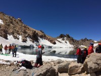
This massif holds Iran's largest glacial region on it including granite jagged peaks and walls and serious coldness and snow falls and unstable weather, unlike most other mountains of Iran winter consists until July at higher parts of this area.
Because of being close to the Caspian sea the humidity of the area is high so usually it's not easy to have a good view from nearby places even if the whole place is not captured in a thick fog.
You can clearly have a good far view from south, a big mass of white snow capped mountains. when you stand on a 3000m~4000m summit like Seechal(3719) or Koloonbastak(4156m) or even the Dizin ski-resort parking (about 3200m) that are about 50Km far from the massif.
Some granite mine works near the massif is the worst fact of the place, and gives the sense of destroying it's great nature. One more bad thing is that there is no mobile service coverage over the area.
Discovery
The Takht-e-Soleiman region was unknown until 1933. Douglas Busk, a British mountaineer, discovered and surveyed the area. Later on, Busk along with Professor Bobek made a detailed survey of this area. In 1936 the north-west ridge (called Germans flank) of Alamkooh was climbed for the first time by German mountaineers, which was considered a great achievement among European climbers.
When To Climb
| Best | For Haftkhan peaks is early August, for central parts is July-August, For east and outer parts is late June |
| Photography | Late spring, the place looks great green including thin clear air and lots of snow on the mountains, a sunny winter day after a snowfall is the best, usually the fog and humidity are the restricts to get a good view. |
| Summer | Sarchal hut may be crowded, numerous minor and some major rock falls happen often, and can cause changes in the routes or be deadly. Anyway you can do the easiest hikes and climbs in summer. |
| Winter | Heavy snow and ice, frequent unexpected storms may last days. It would be a tough and technical attempt, requires technical winter equipments and you must know the region well, specially for Haftkhan peaks it might be the hardest attempt of the whole Alborz. |
Camping
No fees, no permition, but be ware of the avalenches and rock falls before camping.
Skiing
Dizin and other Irainian ski resorts become unusable at may.
While some areas like Takht-e-Soleiman massif and Damavand still contain skiable snow on the higher glaciers and parts of the mountains even till mid summer, fortunately there is no ski lines and elevators installed in these places so this places are still not crowded and ... but I have heard that some Dizin locals carry their ski equipments up the massif and ski at summer.
1) Alam Kooh 4850 m
2) Alam Kooh Shakhak 4782 m
3) Alam Kooh Shakhak approx. 4750 m
4) North Kersan 4680 m (excludes Middle Khersan & Viran Kooh)
5) South Khersan 4659 m
6) Takhte Soleyman Peak 4659 m (excludes many other sub-peaks around it)
7) Siah Sang 4604 m
8) Marji Kesh 4580 m (excludes Marji Kesh)
9) Haft Khan, 4537 m (excludes)
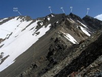
10) Haft Khan , 4528 m PIC 1
11) Chaloon 4516 m
12) South Siah Gook 4510 m
13) North Siah Gook 4505 m
14) Siah Kaman 4472 m
15) Shaneh Kooh 4465 m
16) Haft Khan, 4457 m PIC 1
17) Rostam Nisht 4426 m
18) Kalahoo 4412 m
19) Gardooneh Kooh 4402 m
20) A series of crags known as “Dandaneh Ejhdeha” (Dragon’s Tooth” 4400 m? PIC 1
Some of the more prominent peaks of the massif below 4400 m that are represented on Summitpost by a page or a picture are as follows: (by no means a complete list)
- Ghobi 4399 m, PIC 1, PIC 2
- Menareh 4378 m
- Langari (Haft Khan) Peaks 4376 m & Peak 4324 m
- Mian-Se-Chal 4348 m
- Looy Na (Kalchal) 4340 m
- Tange Galoo 4335 m
- Hezar Cham 4317 m
- Setareh 4296m
- Avidar 4260 m PIC 1 PIC 2
- Lashgarak the Great 4256 m
- Takhte Rostam 4245 m
- Zard Gel 4231 m
- Zarrin Kooh (Aband or Maseh Chal)4198 m
- Lashgarak the Small 4184 m
- Mazi Gardan 4140 m
- Kalvan 4078 m
- Meeshchalak 4067 m
- Alaneh Sar 4065 m
- Nezar 4047 m
- Khers Char 4030 m
- Korma Kooh 4020 m
- Passand Kooh 4000 m
Think, in this battered caravanserai whose
Portals are alternate night and day how
Sultan after sultan with his pomp abode his
Hour or two, and went his way
- Iranian culture2017-09-24
- iran deserts2017-08-23
- iran language2017-08-23
Phone: (+98 21) 88007637 - 88028903
Fax: (+98 21) 88631924
Email: caravan@ircta.com
Web Design & SEO By Sanatech Co.